
SEATTLE — Puget Sound Extended Forecast
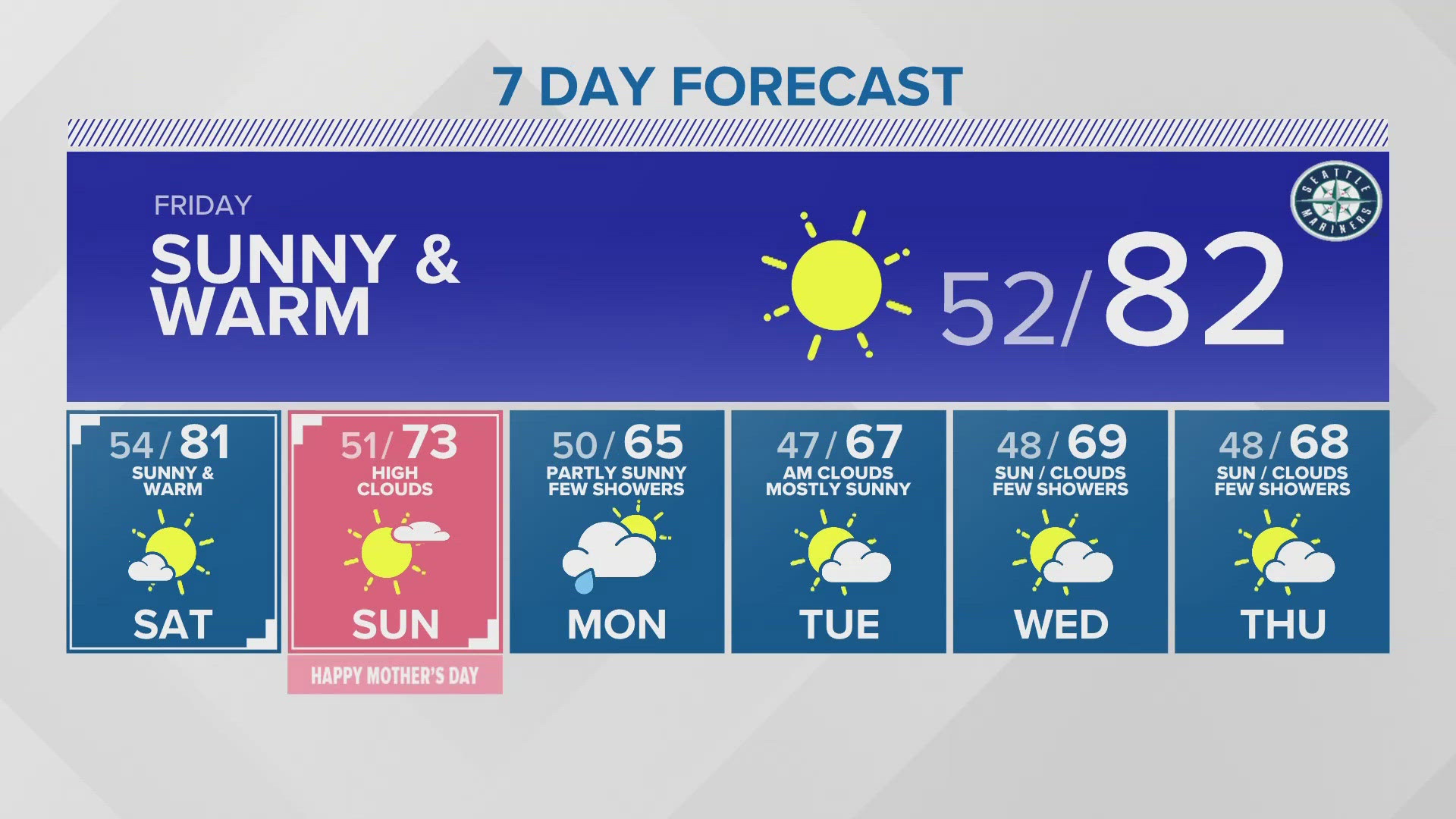
Friday & Saturday: Sunny and warm. Highs in the 70s to low 80s with some mid 80s in the south Sound and south and east of I-5 south of Seattle.
Sunday (Mother's Day): Mostly sunny and cooler. Highs in the low to mid 70s.
Monday: Partly sunny. Chance of a few showers. Cooler. Highs in the mid 60s.
Tuesday: Party sunny. Highs in the mid to upper 60s.
Wednesday & Thursday: Partly cloudy to mostly sunny. Highs in the upper 60s to lower 70s. A few showers are possible.
Discussion:
A large ridge of high pressure is building into western Washington bringing sunshine and warming temperatures. As the high strengthens and builds inland, we will see temperatures continue warm into the weekend.
Offshore winds develop and will cutoff any cooling by marine air. In addition, down slope winds along the west slopes of the mountains will warm by compression and help to push temperatures Friday and Saturday into the upper 70s to low 80s around Puget Sound. There could be a few mid 80s in the south Sound areas and southeast of Seattle and Tacoma.
Although we will be seeing some 80s around the Sound Friday and Saturday, the record high at SeaTac both days is 87° so it's unlikely we'll break any records. Regardless, it will feel like summer both days around Puget Sound.
If you are traveling out to the coast for the end of razor clam season, it will be sunny with highs in the70s to near 80 today and Friday. But onshore winds move in by Saturday for increasing clouds and highs along the beaches dropping back to the 60s for the rest of the weekend.
If you're heading to eastern Washington, everything will be delayed a day. Highs Friday through Sunday will be in the 80s to near 90 degrees and the cooling won't arrive until Monday when highs will drop into the 70s most places. .
Later Saturday and into Sunday, as the ridge moves off to the east we will see winds turn onshore. This will bring in cooler air for Mother's Day. It will still be sunny but a little cooler with highs dropping back to the low to mid 70s.
The onshore winds will pick up Sunday night and Monday as a very weak weather system moves through western Washington. This will spread in clouds and a few showers on Monday, especially in the convergence zone. Highs will cool back to near normal - mid 60s.
Skies will begin to clear on Tuesday and temperatures will warm for midweek!